9/25
We left Huntsville at dawn's early light and traveled 118 miles to Yellow Creek, where we turned into the Tennessee-Tombigbee Waterway. We left the Tennessee River at mile marker 215.3, the number of miles from where the Tennessee River flows into the Ohio River, further "downstream." Our first lock "upstream" was at mile 602, eight days ago. Sometimes the miles are indicated on the navigational aids.
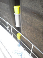
 Going downstream in the locks is so easy. You gently float down, instead of dealing with turbulence when the locks have to filled with water going up the river. These locks have floating bollards that you tie to, and they float down with the boat. This is so much easier than locks on the Welland Canal where two people have to hold onto ropes from the top of the lock to keep the boat near the lock wall. You can see the work load of the "captain" and the "crew"! Life jackets are mandatory.
We heard something new for us on our marine radio today. The Coast Guard announced that captains shouldn't rely on their GPS charts today...they would not be accurate. We were glad we also use paper charts to navigate!
One of our two locks today was the Wheeler Lock. It was named for Joseph Wheeler, a West Point graduate. He was a general in the Confederate Army and a leader of U.S. volunteers in the Spanish-American War. During his military career, he fought in more than 500 skirmishes, commanded in 127 battles, had 36 officers wounded at his side, and had 16 horses shot from underneath him. What a lucky guy! He died in 1906 and is buried in Arlington Cemetery.
In Decatur, AL, we passed under a railway bridge that is on the same site as the bridge burned by the Union Army in 1862 to stop a Confederate advance. I am really enjoying my book on the Civil War. We have traveled or will travel in many of the areas where skirmishes and battles took place. In history class you seem to just learn the important dates and battles. But from the book I am learning interesting details about what was going on between Lincoln and his cabinet, how the personalities of the generals affected their performances on the battlefield...some of them were real dandies!
We are now in Iuka, Mississippi, and 450 miles from Mobile, AL. In the next 250 miles, we will have to go through 10 locks! So farewell until we get internet once again!


Why wasn't the gps going to be reliable?
ReplyDeleteThe coast guard didn't say. We know the government does do it for security reasons. If someone is dropping a bomb, the off-set of the new gps signal will make the target site unreliable.
ReplyDeleteDad
HI Don & Bernadette, Love following your progress, what an amazing trip! You are such a great couple! Love you, Blessings & safe travels, Jean.
ReplyDelete